FieldInsights
Product Specification
Product Name:Flight Services Ground Control Point Installation
Product SKU:71007-04
Revision Date:2023-11-18
Product Overview
Description
Ground Control Point Installation provides for the installation and surveying of ground control points (GCPs) to increase aerial survey accuracy and precisely align FieldInsights Products including Plot (712##-##), Field Scale (713##-##), and Permanent Crop (714##-##). This product is priced and delivered on a per field, per install and survey basis. The price for this product, when delivered by Sentera, requires that Sentera Flight Services is already visiting that field for a separately priced data collection activity (i.e. Flight Services Enterprise Analytics Data Capture (71007-02)).
Recommended Use Cases
- Image Capture
Deliverables Summary
- Ground control point installation and removal.
- Survey and record ground control point locations and elevations, if required by project.
Requirements
General Requirements
- Requires Plot Project Setup (71200-00), Field Scale Project Setup (71300-00), or Permanent Crop Project Setup (71400-00)
- Requires Flight Services Enterprise Analytics Data Capture (71007-02), if GCPs installed by Sentera.
- Requres all Ground Control Point Installation and Surveying Details
Ground Control Point Installation and Surveying Details
Ground Control Point Materials
Sentera typically uses:
- Bucket lids no less than 12 inches (30 cm) diameter. Recommended to use white bucket lids. Avoid green, yellow, and black lids that offer little contrast to crop and soil background
- High-contrast checkerboard or iron-cross patterns of durable material (avoid reflective/glossy finishes) no less than 12 inches (30 cm) in length and width.
- Non-metal (wood or plastic) stakes or flexible wires for securing ground control points in place for extended periods of time. Avoid products that could lead to puncturing equipment tires.
The size of Ground Control Points listed above is a recommendation that works for most projects. Some project requirements may call for larger or smaller ground control points depending on flight altitude, ground sample distance, and specific crop trial details.
Installation and Maintenance
The statement of work or contract agreement for a given project will specify whether Sentera or Customer will perform all installation of ground control points using their own equipment and materials. Materials will be removed from site after data collection is complete for the season.
Ground control points will be installed, typically, at all four corners and each mid-point of the field or trial boundary: typically, 8 total. Alleyways and bare soil at the edges of fields/plot trials are typical locations to place ground control points. A typical ground control point layout is shown in Figure 1.
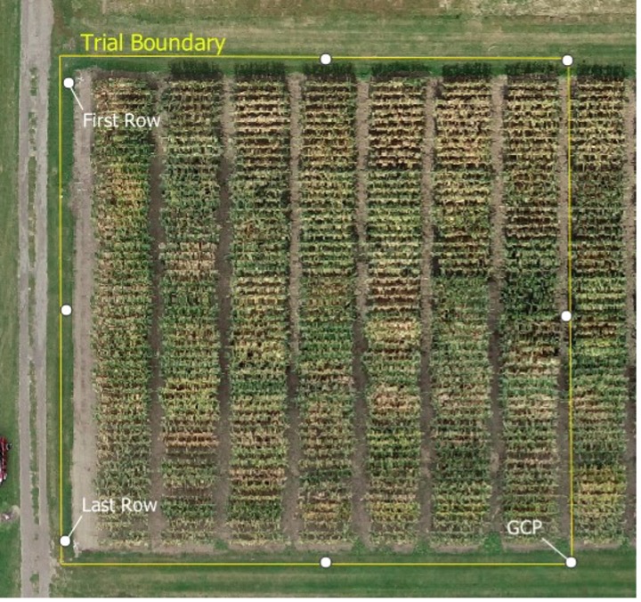 Figure 1: Typical GCP Layout
When required to assist and confirm digital plot grid alignment, ground control points will be installed directly and unambiguously in-line with the first and last rows of crop in a plot trial. This GCP placement location is recommended for all plot trials if space allows. An example is shown in Figure 2.
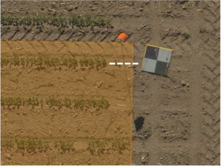 Figure 2: GCPs In-Line with First/Last Row of Trial
The drone pilot is responsible to inspect each ground control point and clear debris such as mud, dust, and other vegetation prior to each data collection flight. Ground control points that have been visibly disturbed or moved due to weather or field activities may have to be re-installed and resurveyed depending on project requirements.
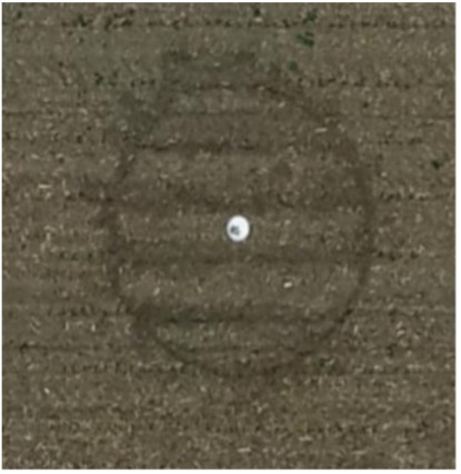 Figure 3: GCP at emergence
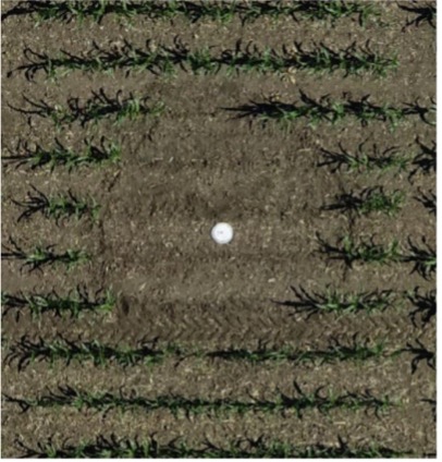 Figure 4: GCP at early-season growth stage
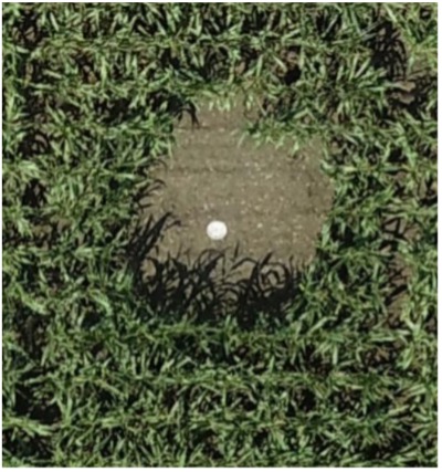 Figure 5: GCP at mid-season growth stage
The customer or trial owner is responsible for in-season maintenance of ground control points. An area clear of vegetation or obstruction must be maintained around the ground control points to remain visible in the aerial imagery over the course of the entire growing season. The cleared space around a ground control point should be at least as big as the height of the crop during the time of image collection. Emergent plants at a height of 6 inches (15 cm) only need 6 inches (15 cm) space clear around all sides of the GCPs to view them in the imagery (Figure 3). Later in the growing season, taller plants should have space cleared of vegetation or obstructions on all sides equivalent to the taller plants around them; for example, 6 feet (2 m) tall corn should have a minimum of 6 feet (2 m) cleared around the point in all directions (Figure 5).
Project requirements for Plot Canopy Height (71206-00) and Plot Canopy Height and Lodging (71206-01) may necessitate additional ground control points placed near the center or interior areas of the trial to obtain an accurate measure of the ground level. This may be trial or site dependent and will be confirmed with the customer prior to installation.
Surveying
For projects requiring survey-grade accuracy for ground control point locations, Sentera or Customer will survey the GCPs using surveying equipment appropriate to the objectives of agricultural plot trial projects. In most cases, accuracies of sub-10 cm can be achieved using a variety of equipment including, but not limited to:
- Propeller AeroPoint Ground Control Points
- Trimble DA2 GPS unit with Catalyst 1 subscription survey (within Trimble VRS network coverage)
- EOS Arrow Gold RTK GNSS Receiver
- Portable RTK GPS system with subscription (Digifarm, Trimble, John Deere, etc.) that allows for point data collection
Ground control point location data in the form of corrected GPS coordinates and elevations will be measured at the center of each Ground Control Point and the recorded data will be submitted along with the imagery to be processed.
When required for data processing, surveyed GCP locations and elevations must be provided to Sentera prior to start data processing. If survey information is not provided within the timeframe specified on the statement of work or contract, Sentera may proceed with data processing using the best available location information in the data, e.g. the standard GPS accuracy locations included in the imagery metadata.
Deliverables
Deliverable Timing
- Ground control points’ installation occurs during first field visit, and before data collection.
Deliverables
- Ground control point installation
- Ground control point removal once both of the following are true:
- Ground control points are surveyed
- All scoped data collection at trial is complete
- When required by the project, Ground control point location data in the form of corrected GPS coordinates and elevations